Quite simply... this was the single hardest day-ride I've ever made. What was at first a disheartening setback, became not only a test of endurance, but ultimately... an adventure of a lifetime.
 |
| Some images will be forever burned into my memory... |
There are no brochures for these places. You'll not find this route on any travel websites. Tourists do not come here for this is not a destination.
If you are very fortunate, as I was... you might stumble across these special places.
 |
| Along a logging road... |
Note: Having just read Brett Pull's lovely report on climbing Kickitat Trail in Washington, I am charged with motivation! So I dedicate this report to you Brett... thanks for the inspiration.
Read Brett's Ride Report at Ride with GPS: Klickitat Trail / Fisher Hill Loop
I set out with a plan. Much of my proposed route, I had cycled previously. That is; I thought I knew where I was going. The keyword being "thought". For much of what made this trip memorable was not at all planned.
Nearly 36 miles into my ride, high along a mountain ridge in the Afan Forest, I hit a road closure. And not just closed... but fenced off from any access by the company installing wind turbines. They had placed a ten foot high fence than ran into the woods and around all that they were working on.
"Oh well." I said to myself; "I'll go around." Or so I thought (insert keyword!).
Elevation: +6,084 ft / -6,083 ft
Duration: 14:48:26

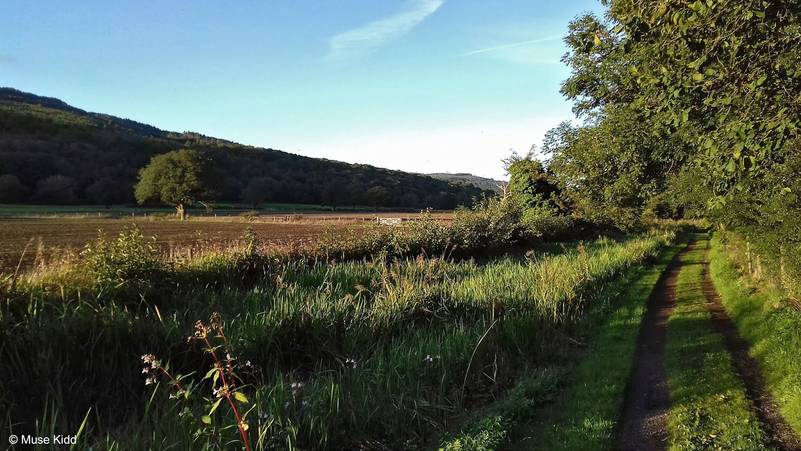
It's important to emphasise that this ride began quietly in a valley, along a river, deep in the woods.


Lady Windsor Trail is part of NCN Route 47 as it runs from Abercynon to Ynysybwl. It's a sleepy little section that sits deep in the forested valley along the River Nant Clydach. I've hardly ever seen a soul cycling on it.


The paved route is not very long at just under three miles and ends where Lady Windsor Colliery once stood. Housing estates sit high above the western side, but you'd never know because it's incredibly quiet and secluded.
| MINI GALLERY
Lady Windsor Colliery
    |
St. Gwynno Forest
Coming off the traffic-free route at Lady Windsor Colliery in Ynysybwl, NCN Route 47 continues on the road for roughly a half mile as you pass the last remnants of village life. The route changes considerably once again as it enters St. Gwynno Forest.


Tightly packed and snaking into woods... it's time to get yer gravel on! There are many signs of logging, but no trucks or workers were to be seen? It's a lovely thick forest now with the smell of freshly cut cedar. Wonderful!


Climbing up and out of the woods, the countryside spreads out all around me as the forest changes over to farming with wide open pastures. Looking back over my shoulder I can see far down the valley from where I started in Abercynon.


Neolithic funeral cairns litter the hillside alongside sheep and stunning vistas. Read more about cairns in Wales at the BBC: From cromlechs to cairns - ancient burial sites in Wales


The world seems to drop away as I near the top. However, once I reach the ridge, the woods reappear as does the logging... only I'm much higher now.


In-between the trees the views open over the valleys to display the Brecon Beacons in the far distance. And I ask myself; "how does such a small country seem so vast?" I'm hardly twenty miles from home.


Robert? Reid? Chaz?... John, Tim, and Deano? Do you see this? Curtis & Jenny, Brett, and Chad... can you feel me name-checking you? You are in my thoughts.


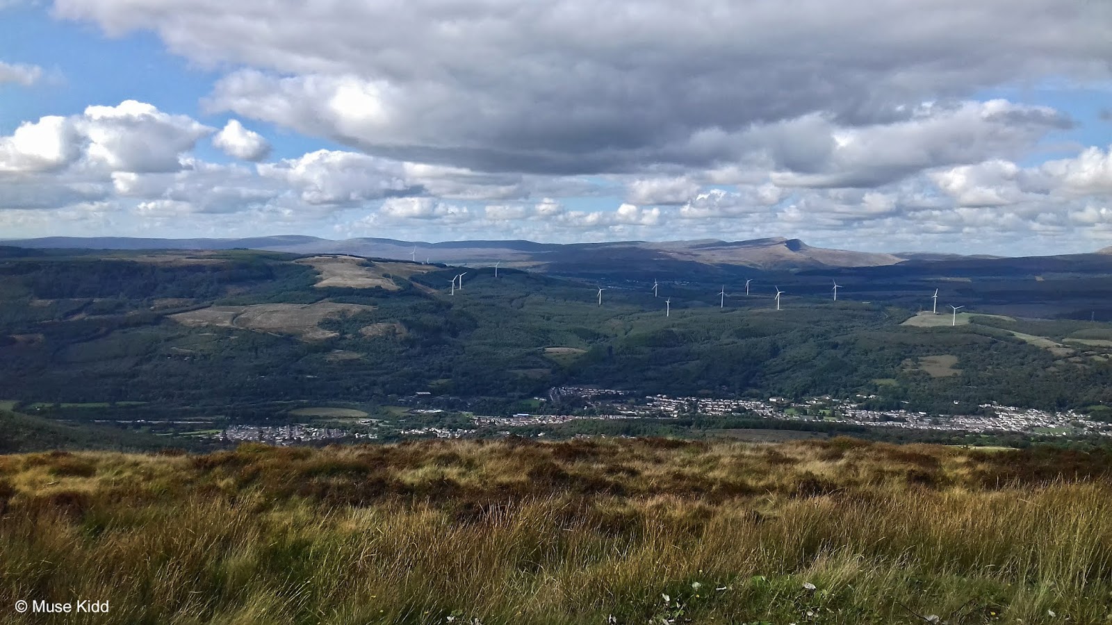
Rounding a corner I find that I've reached the end of the forest. There's a car park just off the road that connects Maerdy to Aberdare (that's a big climb!). On the opposite side, NCN Route 47 continues further up the hill toward a wide ridge populated with wind turbines.


Reservoirs and Wind Farms
Looking back down the valley toward Maerdy, I've actually cycled this next section several times before. It's a good one. NCN Route 881 comes all the way up Cynon Valley from Pontypridd through Maerdy to join NCN 47 just ahead. Can you spot where Castell Nos once stood? You can view more images of this area in my gallery from 2017; Maerdy & Aberdare.


This entire area was once covered in trees and cycling along here was through a thick forest. It's hard to visualise it now for there could not be a more dramatic change. That's Castell Nos Reservoir below, one of two we'll be passing.


I lived in Manhattan for 15 years and I never once thought to photograph anything. I've lived in Raleigh, Chicago, and San Fransisco. I travelled and worked in Boston. None of those places inspired me to pick up a camera. Wales speaks to me.


I am compelled to document this place. For this is a new landscape... a changing landscape. 30 years go, nothing looked as it does today. The Valleys of Wales were dominated by coal production. Thousands of collieries lined these narrow hillsides.


That's Lluest-Wen Reservoir and we're almost to the top of Rhigos Mountain now... having come the scenic way! I'll cross the road and continue on NCN Route 47 which as it turns out, is now a service road for a massive wind farm.


The Rhigos
This is the top of Rhigos Mountain. The A4061 climbs three miles out of the Rhondda Valley from Treherbert and then just as dramatically, drops down the opposite side into Cynon Valley at Hirwaun.
Take a look at my ride; "Twin Peaks: The Bwlch & Rhigos" for a completely different perspective of this climb. It's a popular training route with cyclists.


The shot above is the view looking down the Rhondda Valley toward Treherbert. It's mid-afternoon now. It's a good time and place for a lunch break. I've traveled just under 30 miles and though I've a ways to go, most of the big climbs are behind me.


Starting off again, I immediately enter another wind farm. These turbines are massive!... almost twice the size of those I passed earlier at Lluest-Wen Reservoir (145 metre vs. 84 metre respectively). It's hard to show their scale.
There's also a small cabin with what appears to be emergency supplies? (Peaking through the window I can see loads of bottled water and blankets.) Outside the cabin is a large information board describing the wind turbines and their installation. I don't know who would read the sign because this road is closed to cars? I also don't know why I didn't photograph the cabin?


And then I came across this lovely little sign! I have to admit that I find it very comforting to discover route markers. They have cut many new service roads for the wind turbines and I will warn you now... all the new roads have made navigation a bit of a nightmare. Satellite reception is hit 'an miss, so finding signs is a huge help (hint, hint, Sustrans).

My Garmin picks up a signal, but it cannot draw the maps. In other words, it is completely useless when trying to determine my exact location. Note: This will be a critical factor soon!
I have a paper map, but most of thes new service roads built for the damn wind turbines are not on it. It's a bit unnerving and frustrating.

Meanwhile... I forge ahead presuming that I'm going the correct way.
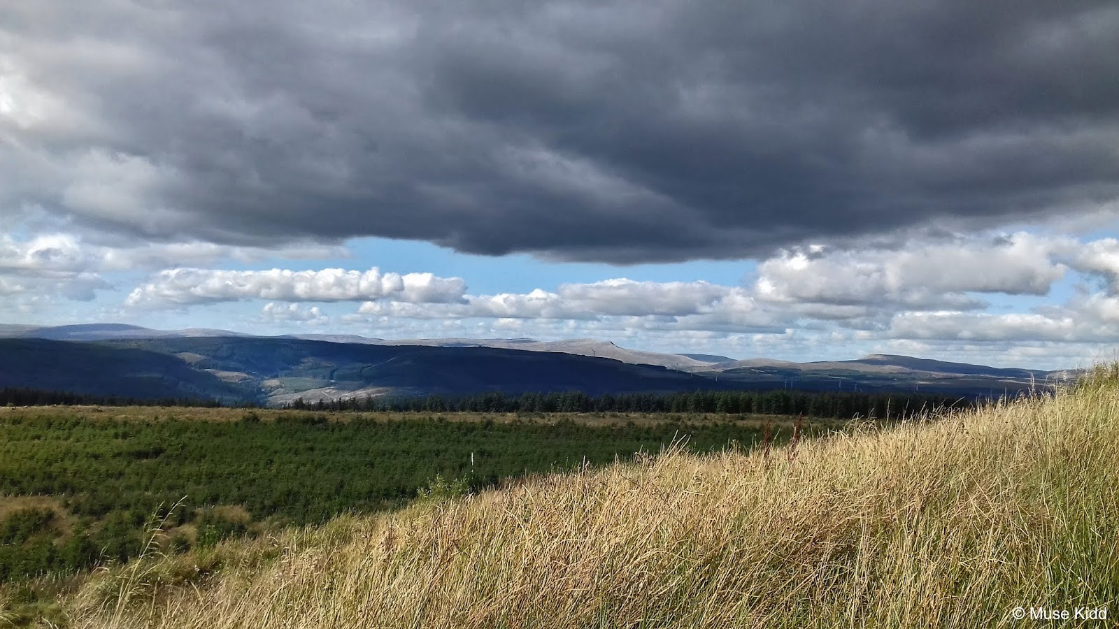
After a few miles ride through the woods, I am shocked to discover that I have curved along the northern ridge from Rhigos Mountain to now find myself high above the valley overlooking Glyneath. This is Neath Valley.


I shot a panoramic to give you a bit of the perspective (although it is of a slightly lower resolution...). I am stood on the precipice of a massive cirque roughly 1,500 feet above the valley floor. The view is simply stunning.


Looking further south down the valley is Blaengwrach and Cwmgwrach. The Neath River is down there too, somewhere. My plan is to follow the Neath and Tennent Canal on my way home, but I've a ways to go first.

A little further along and I can see farther south down the valley to Port Talbot, and Swansea Bay... roughly five miles southwest as a crow flies. Stunning.


There are signs of life, yet I'm all alone on this empty road. I just keep plodding along, thankful for the small signs. (Can you spot the route sticker?)


The Hike
Cue: Dylan's; Pat Garret & Billy the Kid.

And then it happened... the road ahead is closed. There is a very high fence (not climbable with a bike) that crosses the road and continues into the woods to my left. It then encircles the wind turbines as far as I can see to my right.
There is no explanation, just a massive chain and lock on a gate with a big red sign "No Trespassing". I have to make a decision. I can either turn back and ride eight miles to Rhigos Mountain or... head across the moors. I can see a village in the distance... Guess which I chose?


Lifting my bike over a bit of barbed wire, I realise that Neath is out of the picture now. I rolled my bike toward a path further down the hill and began the next segment to my adventure.


Not trying to be overly dramatic, but this three mile walk turned out to be surprisingly difficult. It was rocky and steep and wet and muddy and slippery and unnervingly; I wasn't precisely sure where I was headed. However, I cannot emphasise enough... it was gorgeous!


My Garmin was completely useless. The rough path I was struggling down wasn't on my map. I only had a vague idea where I was when I left the road. Now, I was just following a rough track down the mountain side, heading toward what I hoped would be the river Neath and perhaps, the village of Resolven.
It was getting late in the afternoon. The clouds were worrisome. I had no idea what lay ahead. What distance I had to cover... or how long it might take. I had food and plenty of water, but my greatest worry was that it would be dark by the time I found the village because from Resolven I would then have another 40 miles to cycle home.


Now it's time for me to shut up and just let you look.


It took me well over an hour to see any signs of civilisation. Despite my best efforts, I could only cycle a short distance before I had to dismount and walk again. Even then, walking proved to be difficult at times. I had to be careful on the steep sections not to turn my ankle for it was often rocky and my shoes were not designed for this kind of uneven terrain.


A Discovery of Sorts
I came upon an abandoned building by a small pond. The roof was gone and the walls were falling down. On the far side a metal gate blocked the road over which I had to lift my bike to continue. I suspected that I was entering a private farm. I didn't know what to expect, but if I encountered anyone, I wanted it to be clear that I was just a lost wanderer looking for a way to town.


The road was still quite rocky so I walked slowly, cautiously. I was trying to better assess my situation when suddenly, after about 100 yards I was charged by a large pack of dogs. They were of all shapes and sizes and all were barking loudly, but crucially and surprisingly... not aggressively.
I stopped, called to them, got down on one knee and soon enough they came over. I spoke to them kindly. I held out my hand and the largest one; a black shepherd/labrador mix let me pet him. And then it was as if I was an old friend come to visit. They all changed their tune and became excited; jumping over each other to get near me. I was laughing and petting and saying hello with such gusto that I plopped right on my butt from all the commotion.

The farm was wondrous. As I walked along with my new friends, I was awash in its glorious disrepair. Rusty machinery lay scattered about everywhere, broken and discarded, tall grass wrapped through iron and painted steel.
Beat up trucks, disused tractors; every size and shape were represented amongst the flowering weeds and creaking oaks that lined the road. A junk yard of mechanical splendor wrapped in the silent embrace of mother nature as she slowly pulled everything into the ground.
Standing as if in denial, an odd assortment of lean-tos, shacks and fallen-dawn sheds began to appear as my gang and I ventured deeper. It was a morass of low-tech architecture and broken engineering; a festival of decay.
I was admiring an old Land Rover sat flat on the ground; its tyres gone, the canvas roof in tatters, the seats - merely springs, it's dented shell covered in vibrant moss, a tapestry of colour, when an old man, appeared silently from nowhere and said; "I can let ya have that one for the right price".
His smile was as big and wide as his wrinkled face. He had the sparkle in his eye of a sly wit and I liked him immediately. I walked over, stuck out my hand and introduced myself. Suddenly, the dogs were in heaven again... barking wildly with renewed excitement. "I see you've met my guard dogs.", the old man chuckled.
Of course he had seen me long before I reached the gate... said he'd heard me talking to myself coming over the hill and figured I was lost. Then he looked at me sideways and said; "You're not from around here..." Grinning like an idiot, I replied; "no I'm afraid not".
We walked along together as he pointed out various bits of equipment he was working on or hadn't worked on in twenty years. What that was or why this was the way it was and where it came from and when. He had a story about every piece of junk laying around and I slowly realised that I was having a guided tour. All of these broken bits of machinery were markers, each holding a special place in time, each having a unique meaning like galleries in a museum of his life.
Most all of it wasn't worth working on, but he had the time and liked messing about. "I'm an old man now and I don't have much else left to do"; he said. "These old things can clean up. Scrape the rust off, oil 'em up, and they run... sometimes." He added with that sly smile again.
As we entered a large central area, we came to a stop. We stood there quietly, just looking around. The sun was bright and low over the hillside making shadows stretch long across the road. A few cows rustled behind a gate in a large wooden barn. Their eyes white against the darkness. Their bells clanking flatly with the creaking wood.
Th old man turned and pointed at a stone house connected to the end of the barn; "I was born in that house 85 years ago... and it seems like yesterday. My brothers, my father, his father... we all come from here, but I'm gonna be the last of 'em."
Looking around, he added; "My family don't see no future with this place now and I guess they're right. My kids all moved to the city. That's what happens when ya send 'em to school... they learn that this is hard work and they'd rather sit n'office.
Still, I had it good. I was too young to go to war. My dad started a tinning mill up there on the hill. Me and my brothers worked there for 30 years. And we had this farm too. Always had cows. So I didn't have to go down in the mines. That was hard work... lotta men and boys died down there. Working in the mines was hard."
He looked down. All the dogs had settled around our feet, scratching, looking up at us... looking at the old man. I was sure they had heard all his stories before.
I looked around, trying to take it all in. I looked back at the man, his dogs, his cows, his farm. "You're a lucky man", I said without much thought. He looked up at me and smiled; "Yes, I am."
He told me when his five sisters got married and to who. Which men were drunks and which ones were just no good. He said he had cousins that wanted to take the farm away and put him in a home. Said the county wanted his land for building houses. First made him offers of money and now were trying to force him out. He told me how his wife had died twenty years go and that he missed her every day.
He had a tear in the corner of his eye that caught the sunlight as he gave me that sly smile and winked at me. "It's been real good talking with ya, son. Come back any time", he said.
I had to climb over a gate to get going again. "Can't let them dogs out. They'd follow you all the way ta Cardiff", he chuckled. I shook his hand again. His eyes sparkled. They were as blue and deep as the Mediterranean.

It felt odd at first to be on my bike again. The road was so smooth as I glided away beneath a thick leafy canopy. The temeprature was getting noticeably cooler and I could feel dampness in the air. Within a half-mile, I could hear the rush of falling water ahead of me.

Then quite suddenly, I found myself dropping into in a very deep gorge. What?!?! How? I was just crossing wide open fields... now this? I cannot explain this country. The landscape is bewildering.


What I discovered is in fact Melincourt Falls; an 80 ft. high waterfall popular for hikers in an area that is commonly called Waterfall County. Who knew?!?! You can read more about this spectacular hidden gem at: Melincourt Falls.
I'm in shock. I cannot get my head around all that I've seen today. I can't stay though. I have to get a move on because it's getting late. I'll come back another day when I've more time to explore (perhaps a Bike & Hike is in order?). Meanwhile here is a 360° image I found on Google Maps. Enjoy!

Two miles later and down a very steep descent I find the village of Melincourt. Another mile further I finally enter the Neath and Tennant Canal at Resolven. I have mobile phone service again and my Garmin is working. Time to call my wife.
These were the numbers running through my head: I have only traveled 40 miles since 9:00 am. (It is now 6:30 pm - that's 9 1/2 hours!). I have almost 40 miles to reach home which in all probability take at least five hours to cycle (I have a couple of big climbs ahead of me). It will be dark in approximately one hour. Therefore, I will be traveling for roughly four hours in the dark. Also of note; I am hungry and exhausted. But there's no time for that nonsense... I gotta go!

And of course, it's friggin' gorgeous too. Damnit! The light is wonderful coming through the trees! (Just a quick snap!) But there's no time for lolly-gagging. I gotta go!


Snap! Snap! Snap! What am I doing?!? I must keep going. (Damn it's purdy!) Shut up and go boy. Go!
Looking back...
What a friggin' ride, eh? I am still in awe of it all. It wasn't the longest, but damn it was packed full of interesting stuff. I had such a modest notion for this ride and then, quite surprisingly, it became one of the most epic single-day rides I've had.

| Ride Name: | NCN 47 & Resolven | ||
| Start Date: | Mon. Sept. 12, 2018 | ||
| Starts in: | Oakdale, Wales, GB | ||
| Departed: | 08:54AM | ||
| Distance: | 79.1 mi / 127.3 km | ||
| Elevation: | + 6084 / - 6083 ft | ||
| Max Grade: | 21% | ||
| Duration: | 14:48:26 | ||
| Move Time: | 09:31:06 | ||
| Stop Time: | 05:17:20 | ||
| Max. Speed: | 29.0 mph | ||
| Avg. Speed: | 8.3 mph | ||
| Weather: | sun! | ||
| Temp: | 16°c / 61°f | ||
I made my way from Resolven to Glyneath along the canal path. I then climbed the mountain up and over to Hirwaun where I joined the Cynon Trail back to Pontypridd. The Taff Trail got me back to Quakers Yard and then I was on NCN Route 47 again to Hengoed. Urgh!
The ride home was brutal for it was nearly 11:00 pm when I finally pushed my bike through the garden gate. I was draggin' like a whupped dog.
However, I've got a great idea for next summer - cycling to Neath first and then visiting some of the waterfalls! I would need the long daylight hours for that kinda trip! That could be pretty cool.
Thanks so much taking the (very long) time to read through this bit of nonsense.
Cheers! - cm
▲ Back to top